Showing posts with label Geography (9th). Show all posts

Saturday, March 9, 2024

Sunday, December 31, 2023

CHAPTER 1 INDIA – SIZE AND LOCATION

Q1. Choose the right answer from the four alternatives given below

i. The tropic of cancer does not pass through:

Ans.b) Orissa

ii. The eastern most longitude of India is:

Ans. a) 97°25'E

iii) Uttarakhand, Utter Pradesh, Bihar, West Bengal & Sikkm havecommon frontiers with:

Ans:- Nepal 

iv). If you intend to visit Kavarati during your Summer vacations, which one of the following union territories of India you will be belong to:

Ans. b) Lakshadweep

v) My friend hails from a country which does not share land boundary with India. Identify the country:

Ans. Tajikistan

Q2. Answer the following questions:

i) name the group of islands lying in the Arabian sea 

Ans. The Lakshadweep islands are lying in the Arabian sea 

ii) Name the countries which are larger than India?

Ans. The countries which are greater than India are Russia ,Canada USA, China, Brazil and Australia.

iii) Which Island group of India lies to its South East?

Ans. Andaman & Nicobar Islands.

iv) Which island countries are our southern neighbours?

Ans Srilanka and Maldives are our Southern neighbours.

Q3. The sun rises two hours earlier in Arunachal Pradesh as compared to Gujrat in the west but the watches show the same time. How does this happen?

Ans. From Gujrat to Arunachal Pradesh there is a time lag of two hours hence, time along the standard meridian of India (82°30'E) passing

through Mirzapur (Uttarpradesh) is taken as the standard time for the whole country.

vi) The central location of India at the head of the Indian ocean is considered of great significance why

Ans. The Central location of India at the head of the Indian ocean is considered the countries of East, Africa, West Asia, South and South past Asia and east Asia could be reached through sea routes. Due to it has an easy access to outside world.

CHAPTER 2 PHYSICAL FEATURES OF INDIA

Q1. Choose the right answer, from the four alternatives given below:

i. A landmass bounded by sea on three sides is referred to as:
Ans. Peninsula
ii. Mountain ranges in the eastern part of India forming its boundary with Myanmar are collectively called:
Ans. Purvachal.
iii. The western coastal strip, south of Goa is reffered as 
Ans. Konkan
iv. The highest peak in the Eastern Ghats is:
Ans. Mahendragiri.


Q2. Answer these questions:

i. What is the bhabar


Ans. The rivers, after descending from the mountains deposit pebbles in a
narrow belt of about 8 to 16km in width lying parallel to the slopes of the
Shiwalik. It is known as bhabar.

ii. Name the three major divisions of the Himalayas from North to South


Ans:- Greater Himalayas, Lesser Himalayas & Shiwalik rangearethe three major divisions of the Himalayas from North to South.

iii. Which plateau lies between the Aravalli& the Vindhaya ranges?


Ans. Malwa plateau

iv. Name the island group of India having coral origin?


Ans. The Lakshadweep group of island of India have coral origin.

Q3. Distinguish between:

i.Bhangar and Khandar.


Ans. Bhangar: - The largest part of the Northern Plain is formed of older alluvium. They lie above the flood plains of the rivers and present a terrace like feature. This part is known as Bhangar.


Khadar
: - the soil in this region contains calcareous deposits local known as Kanar. The newer, younger deposits of the flood plain are called khandar. They are renewed almost every year, and so are for intensive agriculture

ii. Western hats and Eastern Ghats:

Western Ghats:


1. Western hats form the western boundary of the Deccan plateau.
2. The average height is 1200 m. But some parts rise to 2480 m or more
3. Its average width is 50-80 km.
4. It is the source of many big-rivers.
5. It is a continuous mountains wall, with passes like the thalGhats and Pal Ghats.

Eastern Ghats:


1. Eastern Ghats form the eastern boundary of the Deccan Plat call. like the Thal Ghats, Bhor
2. The average height is 450 m, rarely exceeding 1200 m.
3. Its average width is 100 to 200 km.
4. No big rivers emerge
5. It is a discontinuous rang as many rivers, Mahandi, Godwari, Krishna,Kaveri, cut the passage to the sea.

 Q4. Which are the major physiographic divisions of India. Contrast the relief of the Himalayan region with that of the peninsular plateau.

Ans:-The major physiographic divisions of India are

1. The Himalayan mountains.
2. The Northern Plains.

3. The peninsular plateau.
4. The Indian desert.
5. The coastal plains.

6. The Islands.

Q:- Differentiate between Himalayan mountains And Peninsular plateau

Himalayan Mountains


i. It consists of loftiest mountains
& deep valleys


ii. It is formed due to the
collusion of the Indo-Australian
& Eurasian plates.


iii. It is formed at the edge of the
Indo-Gagnetic plain


iv. The Himalayan region
contains only a few minerals.


V: The rivers originated from the
Himalayas are perennial.

Peninsular Plateau


i. It consists of broad & shallow valleys & rounded hills.


ii. It is formed due to the drifting & breaking of Gondwana land


iii. It is formed at the edge of the Deccan plateau.
the


iv. The peninsular plateau is the store house of the minerals.  


v. The rivers that originate from the  platea are 
seasonal in nature 

Q5. Give an account of the northern plains of India?


Ans. The Great northern plains extended to about 3200 km between the mouths of the Indus in the west and Ganga in the east. The width varies between 150 + 300 km. width goes on decreasing from West to are broadly divided into three sections. east. The Northern plains


1. Indus Basin: - the indus basin is formed by the Indus and its tributaries. It forms the Western part of the Northern plains, referred to as the
Punjab plaids. The river Sutlej originated from the Mansarovar lake region in Libet, were as the other four rivers Jhelum, Chenab, Ravi, Beas in the Himalayas.


2. The Ganga plain: -The Ganga plain extends between Ghager and Teerta rivers., it is spread over the states of North, India, Haryana,
Delhi, U.P, Bihar, Partly Jharkhand. The Ganga is joined by rivers like Yamuna, Gomiti, Ghara, Ghandak, Kosi, Chambal, Betwaken and son.


3. The Brahmaputra valley: - The Brahmaputra plain is about 650 km from West Bengal to Assam with a general width 90 to 100 km. The Brahamputra and Ganga rivers have formed the world's largest Delta known as Sundarbans.

Q6. Write Short notes of the following:

1. The Indian Deserts:

Ans. The Indian desert lies towards the Western margins of the Aravalli Hills. It is an undulating Sandy plain covered with Sand dunes. This

regions receiver very low rainfall below 150 mm per year. It has arid climate with low vegetation cover. Streams appear during the iny season.

Soon after the disappear into the sand as they do not have enough water to each the sea. Unions the only large river in this region

2. The central Highlands:

The central high lands are bounded by the Vindhya range in the south the Aravalli's on the West and the Chotanagpur pleatue in the east the central highlands merge with the Northern plains of India in the north 

All rivers the central Highland region join the Yamuna and the Ganga from the South. He Central highlands consisting of the following hill

ranges and plateaus.

I. The Aravalli range.

ii. The Vindhaya Range.

iii.The Malwa plateau.

iv.The Bundelkhand

v.The Baghel Khand

vi.The Chota Nagpur

vii. The Shilong plateau.

3. The Island group of India.

Ans. The island groups of India are the Andaman & Nicobar Islands and the Lakshadweep islands.

Andaman and Nicobar Islands: - They are a group 572 islands located in the Bay of Bengal. They are found at an average distance of 1200 km from the main land. Port Blair in the Andaman grou is the capital and port city. The ten-degree channel separates the Andaman group from the Nicobar group.

The Lakshadweep islands:

It is a group of 36 islands located in the Arabian Sea. These islands lie 300

km to the west of the coast of Kerala. All these islands have been built up

by coral polyps and have fringing very close to their shores.

CHAPTER 3 DRAINAGE

Q1. Choose the right answer from the four alternatives given

i.In which of the following states the Wular lake located:

Ans. d) J&K.

ii. The river Narmada has its source at:

Ans. d) Slopes of the Western Ghats

iii. Which one of the following lakes is a salt water

Ans. b) Sambhar

iv. Which one of the following is the longest river of the peninsular india 

Ans. C) Godavari

v. Which one of the following river flows through rift valley

d) Tapi

Q2. Answer the following questions briefly.

i. What is meant by a water divide. Give an example.

Ans. When an elevated area, such as a mountain or an upland, separates two drainage basins. Such an, upland is known as a water divide.

ii. Which is the largest river Basin in India.

Ans.Ganga is the largest river basin in India.

iii. Where do the rivers Indus and Ganga have their origin.

Ans. The river Indus have origin in Tibet, near lake Mansarovar.

The river Ganga have its origin from Gangotri glacier.

iv. Name the two head streams of the Ganga. Where do they meet to form the Ganga?

Ans. Bhagirathi & Alaknanda are the two head streams of the Ganga. They meet at Haridwar to form the Ganga.

v. Why does the Brahamputra in its Tibetan part have less silt, despite a longer coarse.

Ans. In Tibet the Brahamputra carries less silt as it is a cold, dry area& flows in a smaller volume of water.

vi. Which two peninsular rivers flow through trough.

Ans. The two peninsular rivers flow through trough are Narmada and Tapi river.

vi. Sate some economic benefits of rivers and lakes.


Ans.Rivers and lakes have been of fundamental importance throughout the
human history, water from the rivers is a basic natural resource. Using
rivers for irrigation, navigation, hydroelectricity is of special significance

Q3. Say weather the following water bodies are natural or mam made


a. Wular
b. Dal
c. Nainital
d. Bhimtal
e. Gobind Sagar
f. Loktak
g. Barapani
h. Chilika
i. Sambhar
j. Rana Pratap Sagar
k. Nizam sagar
I. Pulicat
m. Nagarjuna sagar
n. Hirakund

Ans.

natural

natural

natural

natural

Human-

natural

natural

natural

natural

Man-made

Man-made

natural

Man-made

Man-made

Q4. Discuss the significant difference between the Himalayan and the peninsular rivers?

Ans:-

Himalayan rivers


1. Most of the Himalayan rivers are perennial it means they have water through out the year


2. They originates from the lofty northern Himalyans.

3. They are long rivers.

4. They have large flow of water in their Chantal's.


5. They got water from glaciers as well as rain fall.


6. Examples are Indus, Ganga, Brahamputra etc.

Peninsular Rivers

1.Most of the peninsular Rivers are seasonal in nature

2.They originate from the Peninsula

3. They are short rivers.

4. They have reduced flow of water in their channels. Jharkhand, Karnataka etc. 

5. They got water mostly from rain flow.

6. Examples are Narmada Mahandi and Tapi basin.

Q5. Compare the eats flowing and the west flowing rivers of the Peninsular plate?


Ans.

East flowing rivers


1. The east flowing rivers such as, Mahanadi, the Godawari, the Krishna and the Kaveri drains into bay of Bengal.


2. The rivers make deltas at their mouths.


3. The basin of Eastern flowing rivers are large.


4. the tributaries of the east flouting rivers are long.


5. The basis of east flowing rivers covers Maharashtra, MP, Orissa, Andhra Pradesh, Jharkhand , Karnataka

West flowing rivers

1. The West flowing rivers such as Narmada and the Tapi Drain into the Arabian Sea. peninsula. 

2.These rivers make actuaries at their mouths.


3. The basin of west flowing rivers are smaller as compare to east flowing rivers.


4. The tributaries rivers west flowing rivers are very short.


5. The basin of East flowing covers M.P Gujarat and Maharashtra.

Q6. Why are rivers important for the country's economy.


Ans.Rivers are important for the country's economy because the water of rivers is used for the agricultural and the industrial purposes. The rivers are the important sources for the generation of hydroelectricity which is the backbone of our industrial progress

CHAPTER 4 Climate

1. Find out why the houses in Rajasthan have thick walls and flat roofs.


Ans. Houses in Rajasthan have thick walls and flat roofs. The thick walls do not allow the heat to get into the houses while the flat roofs retain the little water that comes as rain in the desert.

2. Find out why is it that the houses in the Tarai region and in Goa and Mangalore have sloping roofs.


Ans. The Tarai region, Goa and Mangalore receive heavy rains during monsoon seasons thus the houses have sloping roofs so that the rainwater flows off the roof.

3. Why are houses in Assam built on stilts.


Ans. The houses are built on stilts in Assam as there is danger of floods and wild animals in large areas of Assam.

4. Why most of the world's deserts are located in the western margins of continents in the subtropics.


Ans. Most of the world's deserts are located in the western margins of continents in the subtropies because trade winds that blow in the region shed their moisture on the the eastern side. They become dry by the time they reach the western margin of the continent. Cold ocean currents also tend to stabilise the air over the coast and inhibit cloud formation.

Exercise

1. Choose the right answer from the four alternatives given below:

(i) Which of the following places receives the highest rainfall?


(a) Guwahati
(b) Mawsynram
(c) Kolkata
(d) None of these


Ans.(b) Mawsynram

(ii) The wind blowing in the northern plains in summers is known as:


(a) Kaalbaisakhi
(b) Loo
(c) Trade winds
(d) None of the above


Ans .(b) Loo

(iii) Which one of the following causes rainfall during winters north-western part of India?


(a) Cyclonic depression
(b) Retreating monsoon
(c) Western disturbances
(d) Southwest monsoon


Ans (a) Cyclonic depression

(Iv) Monsoon arrives in India approximately in 


(a) Early May
(b) Early July
(c) Early June
(d) Early August


(c) Early June

(v) Which one of the following characterises the cold weather in India?


(a) Warm days and warm
nights
(b) Warm days and cold nights
(c) Cool days and cold nights
(d) Cold days and warm nights


Ans:-(b) Warm days and cold nights

2. Answer the following questions briefly.

(i) What are the controls affecting the climate of India?

Ans. The elements affecting the climate are Latitude, Altitude and Pressure & Winds, distance from the sea (continentally), ocean currents  and relief features.

ii) Why does India have a monsoon type of climate?

Ans. India have a monsoon type of climate because the climate of India is governed by the monsoon winds which are limited between 20° North and 20° South.

iii) Which part of India does experience the highest diurnal range of temperature and why?

Ans. The Indian desert located in the north-western part of India experience the highest diurnal range of temperature because of the sand present there quickly becomes hot during day and cools down rapidly  during night.

iv) Which winds account for rainfall along the Malabar coast?

Ans.Malabar Coast gets rains from South-West Monsoon Winds,

v) What are Jet streams and how do they affect the climate of India?

Ans.Jet streams are high velocity westerly winds bowing through a narrow zone in the upper troposphere. The westerly flows are responsible for the western disturbances experienced in the north and north-western parts of the country. The easterly jet streams cause tropical depressions during the monsoon as well as October November months.

(vi) Define monsoons. What do you understand by "break" in monsoon?

Ans.Monsoon refers to the seasonal reversal in the wind direction. Monsoon 'break' refers to the happening of wet and dry spells during the rainy season. The monsoon rains take place only for a few days at a time.

vii) Why is the monsoon considered a unifying bond?

Ans. The monsoon is considered a unifying bond because:

i. The Indian landscape, its flora and fauna, etc. are highly influenced by the monsoon

ii. These monsoon winds bind the whole country by providing water for agrical activities

III . Most of the festivals in India that are related to agricultural cycle may be known by different names in different parts of the country, but their celebration is decided by the monsoon.

IV. Year after year, people of India from north to south and from east to west, eagerly await the arrival of the monsoon.

v. The river valleys which carry this water also unite as a single river valley unit.

3. Why does the rainfall decrease from the east to the west in Northern India.

Ans. The Bay of Bengal branch of south-west monsoon moves towards northeast carrying more moisture and they give heavy rainfall in this region. As they move further towards west, they carry less content with themselves resulting in decrease in rainfall in the west

4. Give reasons as to why:

i) Seasonal reversal of wind direction takes place over the Indian subcontinent.

Seasonal reversal of wind direction over the Indian subcontinent takes place due to pressure differential. El Nino has major  role to play in the seasonal reversal of wind direction over the Indian subcontinent.

ii) The bulk of rainfall in India is concentrated over a few months.

 The monsoon begins from the first week of June and advances quite rapidly to cover almost the whole country by mid-July. Hence, the bulk of rainfall in India concentrated over the months of a few months; mainly June to August.

iii) The Tamil Nadu coast receives winter rainfall.

Ans:- The Tamil Nadu coast recaves winter rainfall because of movement of to the Bay of Bengal.

iv) The delta region of the eastern coast is frequently struck by cyclones.

The Bay of Bengal is the centre of various pressure changes and hence there is Always a chance of development of cyclone. Due to this, the delta region of the eastern coast is frequently struck by cyclones.

v) Parts of Rajisthan , Gujarat and the leeward side of the Western drought-prone.

The parts fall in the rain shadow area of the Aravalli. Hence, they are drought prone as they don't receive much of rainfall.

5. Describe the regional variations in the climatic conditions of India with the help of suitable examples.

Ans. There is regional variation in the climatic conditions of India. Temperature and Precipitation vary from place to place and season to season.

i. In summers the temperature rises up to 50°C in parts of Rajasthan, whereas it may be around 20°C in Pahalgam in Kashmir.

ii.In winters night temperature in Drass in Kashmir may be minus 45 whereas in Tiruvanantapuram in Kerala may have a temperature 20°C.

iii. In Andaman Islands the difference between day and night tenperature may be hardly 7° -8°C.

iv. Coastal areas experience less contrast in the temperature, whereas seasonal contrasts are more in the interior of the county

v. There is decrease in rainfall generally from eastwest in the northern plains

vi. Most part of India receive rainfall from June to September, whereas some parts like the Tamil Nadu coast gets large portion of its rain during October and November.

6. Discuss the mechanism of monsoons.

Ans.Following are the factors responsible for the mechanism of monsoon:

i. The differential heating and cooling of land and water creates low pressure on the landmass of india while the seas around experience comparatively high pressure 

II . The inter tropical convergence Zone (ITCZ) is normall positioned about 5°N of the equator. It shifts over the Ganga plains during summer. It is also known the monsoon trough during the monsoon season. 

iii. The high pressure area, east of Madagascar is approximately 20°S over the Indian Ocean. This area affects the Indian Monsoon.

iv. The Tibetan plateau gets intensely heated during summer. This results in strong vertical air currents and formation of high pressure over the plateau. This high pressure zone is about 9 km above the sea level.

v. The westerly jet stream moves to the north of the Himalayas, and the tropical easterly jet stream moves over the Indian Peninsula during summer.

vi. The periodic change in pressure conditions between Pacific Ocean and the Indian Ocean that is known as the Southern Oscillation or SO also
affects the monsoon.


vii. The difference in pressure over Tahiti and Darwin is computed to predict the intensity of the monsoons. Tahiti (18°S/149°W) lies in the
Pacific Ocean and Darwin (12°30'S/131°E) lies in northern Australia if the pressure differences are negative, it means a below average monsoon.

7. Give an account of weather conditions and characteristics of the cold season.


Ans. Following are the features of the cold season:


i. The winter season begins from mid-November and till February; in northern India.

ii. December and January are the coldest months in the Northern part of India


iii. The temperature ranges between 10⁰ to 15⁰C
it ranges between 24°-25°C in Chennai


iv. Days are warm and nights are Cold.


v. Frost is common in the north and the higher slopes of Himalaya experience snowfall.


vi. The northeast trade winds prevail over the country in this season as these winds blow from land to sea most parts of the country experience dry season 

vii. The weather is usually marked by clear sky, low temperatures and low humidity and weak variable winds .

viii. The inflow of the cyclonic disturbances from the west and the northwests is a characteristic feature of the cold weather over the northern plains 

ix These low-pressure systems originate over the Mediterranean Sea and Western Asia and move into India. They cause winter rains over the plains and snowfall in the mountains.


x. The winter rainfall is in small amount but is very important for the rabi
crop. This rainfall is locally known as mahawat.

xi. The peninsular region does not have a well- defined cold season due to the moderating influence of the sea.

8. Give the characteristics and effects of the monsoon rainfall in India.

Ans. The characteristics of the monsoon rainfall in India:

i. The duration of the monsoon varies from 100 to 120 days from early June to mid- September.

ii. Around the time of its arrival, the normal rainfall increase continues regularly for several days. This is called the 'burst' of the monsoon 

iv. The monsoon arrives at the southern tip of the generally by the first week of June.

v. The rainfall is unevenly distributed across The country  

Effects of the monsoon rainfall in India:

i.Agriculture in India largely depends on Indian monsoons for water. Late, Low or excessive rains have a negative impact on crops.

ii. Due to uneven distribution of rainfall across the country, there are few places that are drought prone and few are flood affected.

iii. The monsoon provides India with a diverse climatic pattern. Hence, in spite of the presence great regional variations, it has a unifying influence upon the country and its people.

Q.what is climate /weather

the weather conditions cold ,rain dryness prevailing in an area in widespread or over an extended period of time is called weather of that  place.

Q. What is climate Change 

Ans.Climate change refers to long-term shifts in temperatures and climate patterns. These shifts can be natural, but since the 1800s-1900s, human activities had been the primary driving force of climate change, commonly because of the burning of fossil fuels (like coal, oil, and gas), which produces heat-trapping gases.

Q. What are the causes of climate change

Ans.The following are the main  causes of climate change;

1.Power generation :-

Generating power by using hydro or by using fossil fuels causes climate change on earth

2.Manufacturing goods:-

Manufacturing more and more goods for human consumption and utilisation  is another cause of climate change

3.Cutting of forests:- 

Cutting forests for cultivation as well as for the construction of factories and housing colonies  or  for the extension of cities and towns to Full fill the human resedensial needs is another cause of climate change

4.Using transportation :-

Using modern  means of transportation like cars ,Buses,trains ,ships and aeroplanes and their exhaust also cause the climate change

5 producing foods:- Clearing more and more forest land for cultivation and  food production to meet the food need of growing population of word is another cause of climate change

6.Powering building:- in order to meet the electricity needs  of the large buildings and  sky scrapers by burning more and more fossil fuels or by  to produce electricity by using water from rivers is another cause of climate change

7.Comsuming of too much resources:- Consuming too much resources (over exploitation) with out taking judicious use of resources in to consideration  is also another cause of climate change

CHAPTER 5 Natural Vegetation & Wildlife Geography

Question 1. Choose the right answer from the four alternatives given below

(i) To which one of the following types of vegetation does rubber belong to ?

(a) Tundra
(b) Tidal
(c) Himalayan
(d) Tropical Evergreen

Answer (d)

(ii) Cinchona trees are found in the areas of rainfall more than

(a) 100 cm
(b) 50 cm
(c) 70 cm
(d) less than 50 cm

Answer (a)

(iii) In which of the following states is the Similipal bio-reserve located ?

(a) Punjab
(b) Orissa
(c) Delhi
(d) west Bengal

Answer (b)

(iv) Which one of the following bio reserves of India is not included in the world network of bioreserve?

(a) Manas
(b) Nilgiri
(c) Gulf of Mannar
(d) Nanda Devi

Answer (a)

Question 2. Answer the following questions briefly

(i) What is a bioreserve? Give two examples

Answer A bioreserve is an area in which the flora and fauna of the given country is protected and there are certain researches which are done on them. It is an area containing a wildlife preserve bordered by a buffer zone in which more frequent use is permitted to the public, established as a way of integrating habitat conservation with the interests of the local community.

Examples are Rajaji in Uttarakhand and Simlipal in Orissa.

(ii) Name two animals having habitat in tropical and montane type of vegetation.

Answer Animals found in Tropical forests are lion. tiger. pig, deer and elephant.

Animals found in Montane forests are Kashmir stag, spotted deer, wild sheep, jack rabbit, Tibetan antelope, yak, snow leopard, squirrels. shaggy horn wild ibex. bear and rare red panda, sheep and goats with thick hair.

Question 3. Distinguish between

(i) Flora and Fauna
(ii) Tropical Evergreen and Deciduous Forests

Answer (i) Difference between Flora and Fauna

Flora

All the plant species observed in a given place at a given time is known as the flora of that place.

Fauna

All animal species observed in a given place at a given time is known as the fauna of that place.

(ii) Difference between Tropical Evergreen and Deciduous Forests

Tropical Evergreen ForestDeciduous Forest
Tropical evergreen forest grows in areas with average annual rainfall over 200 cm followed by a short dry season.Deciduous forest grows in areas with average annual rainfall between 70 – 200 cm.
Trees of these forest remain green throughout the year.At a specific season, the trees drop all their leaves and stand bare.
Common trees of this forest are—ebony, mahogany, rosewood, rubber and cinchona, etc.Common trees of this forest are— Teak, bamboo, sal, shisham, sandalwood, khair, kusum, arjun, mulberry, etc.
Common animals of this forest are—elephants, monkeys, lemurs, deer, birds, snakes, bats, sloths, scorpions, snails, etc.Common animals of this forest are— lion, tiger, pig, deer and elephant, birds, lizards, tortoise, snakes etc.

Question 4. Name the different types of vegetation found in India and describe the vegetation of high attitudes?

Answer:The following major types of vegetation are found in India

Tropical Evergreen Forests
Tropical Deciduous Forests
Tropical Thorn Forests and Scrub
Montane Forests
Mangrove Forests
Vegetation of High Altitude (Montane Forests)

In mountainous areas, the decrease in temperature with increasing altitude leads to a corresponding change in natural vegetation.
The wet temperate type of forests are found between a height of 1000 and 2000 metres, where evergreen broad leaf trees such as oaks and chestnuts predominate.
Temperate forests containing coniferous trees like pine, deodar, silver fir, spruce and cedar are found between 1500 and 3000 metres.
These forests cover mostly the southern slopes of the Himalayas, places having high altitudes in southern and north east India.
Temperate grasslands are common at higher elevations.
At high altitudes, generally more than 3,600 metres above sea level, alpine vegetation is found. Silver fir, jumpers, pines and birches are the common trees of these forests.

Question 5. Quite a few species of plants and animals are endangered in India? Why?

Answer

Many plants and animals in India are endangered because of the greediness of human beings for their commercial value. Humans are hunting animals for their skins, horns and hooves which are In demand and give a lot of profit.
Deforestation on a wide scale destroys the habitat of animals and also leads to decline of the different species of trees and plants. Ecological balance is disturbed due to deforestation, which is harmful for both flora and fauna.

Question 6. Why has India a rich heritage of flora and fauna?

Answer: India has rich heritage of flora and fauna because of the following factors

It has a very large geographical area which includes the mountains, the Northern plains, plateaus and also islands.
India has a varied climate from very dry to monsoon type and temperature ranges from very hot to cold and very COld, which is suitable for different kinds of flora and fauna.
India has different types of soil like alluvial soil, red soil and black soil suitable for different plant types.
India is blessed with perennial rivers which sustain aquatic life apart from supporting different kinds of flora and fauna.
The mountains and plains are capable of supporting and sustaining different kinds of plants and trees and provide an environment and habitat for various Kinds of animal species.
India is one of the twelve mega biodiversity countries of the world. It has about 47,000 plant species. It stands at the tenth place in the world and fourth in Asia in plant diversity. It has 89,000 species of animals as well as a rich variety of fish. It has about 15,000 flowering plants and ferns. India is blessed with different types of soils, climatic conditions and physical features and thus, it is suitable for supporting different species of flora and fauna
making it a biodiversity hot spot.

Map Skills

On an outline map of India, label the following.

Areas of Evergreen Forests
Areas of Dry Deciduous Forests
Two national parks each in northern, southern, eastern and western parts of the country.
Answer (i) and (ii)

NCERT Solutions for Class 9th Social Science Geography Chapter 5 Nature Vegetation & Wildlife

The Evergreen forests are labelled as ‘Tropical Evergreen Forest’

The Dry Deciduous Forests are those parts of the forests labelled Tropical Deciduous Forests which have rainfall between 70 and 100 cm annually. They are found in the rainier part of the Peninsular plateau and the plains of Bihar and Uttar Pradesh.

(iii) Some National Parks in the four regions of India are listed below. For their exact locations, refer to the map on page 49 of the textbook

NCERT Solutions for Class 9th Social Science Geography Chapter 5 Nature Vegetation & Wildlife

Project / Activity

Find some trees in your neighbourhood having medicinal values.
Find ten occupations getting raw material from forests and wild life.
Write a poem or paragraph showing the importance of wild life.
Write the script of a street play giving the importance of tree plantation and try to enact it in your locality.
Plant a tree either on your birthday or one of your family member’s birthday. Note the growth of the tree and notice in which season it grows faster.
Answer

Some trees having medicinal values are (there are many others)
Amla Plant or Indian Gooseberry This is one of the richest sources of Vitamin C. It is a medium size deciduous plant, which attains a height of 8 to 18 meters. Amla is used to make herbal products, which helps get rid of health-related problems like hair fall, haemorrhage, leucorrhoea, skin diseases and discharge of blood from uterus.
Neem Tree It plays a significant role in Ayurvedic medicine. It helps to treat chickenpox, fever, skin disease and headache
Eucalyptus It is a tall tree, with heights up to 100 metres. Oil taken out of the Eucalyptus leaves has great medicinal value. It helps in purifying blood and lowering of blood sugar level. It cures problems of asthma, bronchitis, cardiac problems and fungal Infections.
Occupations getting following raw materials from forests and wildlife
Carpentry
Rubber industry
Leather industry
Ayurvedic medicine manufacturing
Paper industry
Glue industry
Fruit and food production industry
Hunting
Resin extractor
Perfume Industry
Importance of Wildlife Wildlife comprises of the numerable varieties of wild plants, animals, fungi and microorganisms that exist on our planet Earth, rather than just cultivated plants and domesticated animals. We largely depend on this wildlife for every elementary requirement in our lite.
The food we eat, the clothes, we wear, the medicines we consume, a variety of building materials used for construction, numerous chemicals used for manufacturing our necessities, all are extracted from the wildlife existing around us. About 40,000 species of plants, animals, fungi and microscopic animals benefit us in some way or the
other. The normal functioning of the biosphere depends on endless interactions amongst animals, plants, and microorganisms.

This, in turn, maintains and improves human life further. These ecological processes are vital for agriculture, forestry, fisheries and other processes that support human life. Besides, there are several biological. processes wherein wildlife plays a key role, such as pollinisation. germination, seed dispersal, soil generation, nutrient cycling, habitat maintenance, waste breakdown, and pest control.

Chapter 6 Population

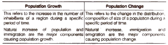
Question 1.Choose the right answer from the four alternatives given below

 (i) Migrations change the number, distribution and composition of the population in

(a) the area of departure
(b) the area of arrival
(c) Both the area of departure and arrival
(d) None of the abov

Answer(c)

(ii) A large proportion of children in a population is a result of

(a) high birth rates
(b) high life expectancies
(c) high death rates
(d) more married couples

Answer(a)

(iii) The magnitude of population growth refers to

 (a) the total population of an area
(b) the number of persons added each year
(c) the number of females per thousand males
(d) the rate at which the population increases

Answer(b)

(iv) According to the census, a ‘literate’ person is one who

(a) can read and write his/her name
(b) can read and write any language
(c) is 7 years old and can read and write any language with understanding
(d) knows the 3 ‘R’s (reading, writing, arithmetic)

Answer(c)

Question 2. Answer the following questions briefly.

(i) Why is the rate of population growth in India declining since 1981?

Answer

Since 1981, the rate of growth started declining gradually, because of popularised.

(a) Family planning measures were adopted, leading to decline in the birth rate.

(b) Awareness about advantages of small family came to be recognised.
(c) There was a growth of nuclear families occured which adopted the small family norm.
(d) Promotion of family planning programme by the government.

(ii) Discuss the major components of population growth.

Answer :The major components of population growth are birth rates, death rates and migration.

The natural increase of population is the difference between birth rates and death rates.

Birth RateBirth rate is the number of live births per thousand person in a year. It is a major component of growth, because in India birth rates have always been higher than death rates.

Death RateDeath rate is the number of deaths per thousand persons in a year. The main cause of the rate of growth of the Indian
population has been the rapid decline in death rates.

Migration Migration is the movement of people across regions and territories. Migration can be internal (within the country) or international (between the countries).

Internal migration does not change the size of the population, but influences the distribution of population within the nation.

(iii) Define age structure, death rate and birth rate.

Answer: Age Structure Agestructure means the number of people in different age groups in a given population.

Death RateDeath rate is the number of deaths per thousand persons In a year.
Birth RateBirth rate is the number of live births per thousand persons in a year.

(iv) How is migration a determinant factor of population change?

Answer: Migration a Determinant Factor

  • Migration is the movement’ of people across regions and territories.
  • Migration can be internal (within the country) or international (between the countries).
  • Migration is a determinant factor of population change as it changes its size and composition.
  • Internal migration does not change the size of the population but influences the distribution of population within the nation.
  • In India, most migrations have been from rural to urban areas because of the ‘push’ factors in rural areas. These push factors are adverse conditions of poverty and unemployment in the rural areas. The ‘pull’ factors of the city are In terms of increased employment opportunities and better living conditions.
  • These ‘push’ and ‘pull’ factors have led to increased migration from rural to urban areas and rapid rise in the urban population.
  • There has been a significant increase in the number of ‘million plus cities’ from 25 to 35 in just one decade i.e., 1991-2001.

Question 3. Distinguish between population growth and population change.

AnswerThe differences between population growth and population change are given in the table below

Question 4.What is the relation between occupational structure and development?

AnswerThe distribution of the population according to the different types of occupations is referred to as the occupational structure.

  • Occupations are generally classified as primary, secondary and tertiary.
  • Primary activities include agriculture, animal husbandry, forestry, fishing, mining and quarrying, etc.
  • Secondary activities include manufacturing industry, building and construction work, etc.
  • Tertiary activities Include transport. communications, etc.
  • The proportion of people working in different activities varies in developed and developing countries.
  • Developed nations have a high proportion of people in secondary and tertiary activities.
  • In India about 64% of the population Is engaged only in agriculture.
  • The proportion of the population dependent on secondary and tertiary sectors is about 13 and 20% respectively.
  • There has been an occupational shift in favour of secondary and tertiary sectors because of growing industrialisation and urbanisation in recent times.

Question 5.What are the advantages of having a healthy population?

Answer:Health is an important component of population composition

which affects the process of development. So we need a healthy population.

(a) The health of a person helps him/her to realise his/her potential and gives the ability to fight illness.
(b) A healthy person is an asset to the country, is more productive and helps in the progress of the country.
(c) A healthy person is able to earn more and Improve his standard of living.
(d) A healthy population makes a healthy and strong nation economically and socially.

Question 6.What are the significant features of the National Population Policy 2000?

Answer:  Aims/Objectives of National Population Policy 2000

  • Imparting free and compulsory school education upto 14 years of age.
  • Reducing infant mortality rate to below 30 per 1000 live births.
  • Achieving universal immunisation of children against all vaccine preventable diseases.
  • Promoting delayed marriage for girls.
  • Making family welfare a people centered programme.
  • Protection of adolescent girls from unwanted pregnancies.
  • Protection of adolescents from Sexually Transmitted Diseases (STD) and educating them about the risks of unprotected sex.
  • Making contraceptive services ‘accessible and affordable.
  • Providing food supplement and nutritional services.
  • Strengthening legal measures to prevent child marriage

Tuesday, May 2, 2023

Chapter 7 Geography of Jammu & Kashmir and Ladakh

1. Answer the following questions :-

i. Explain the major physical divisions of Jammu, Kashmir and Ladakh?

Ans:The Union Territory of Jammu & Kashmir and the Union Territory of Ladakh are divided into the following physiographic regions:

I. Outer Plains: Fertile lowlands with rivers supporting thriving agriculture.

II. Shiwaliks: Young hills with rich biodiversity, serving as an ecological buffer zone.

III. Middle Himalayas: Scenic ranges with diverse landscapes, influencing regional climate.

IV. Valley of Kashmir: Picturesque valley, fertile soil, famous for saffron and apples.

V. Ladakh Region: High-altitude desert with a unique culture, popular for adventurous tourism.

ii. Name the areas of Jammu Division which are covered by the alluvial plains?

Ans: Areas of jammu division which are covered by the alluvial plains are :

1. Kathua

2. Akhnoor

3. Hiranagar

4. Bishnah

5. R.S Pura

6. Domana

These regions are characterized by fertile soils deposited by rivers and are suitable for agriculture, making them productive crop lands in the region.

iii. Discuss the main features of climate of Ladakh

Ans: Ladakh experiences a cold and arid climate, resembling a cold desert. It has extreme heat and cold variations, with very low precipitation, mainly as snow. Sun and shade temperatures differ significantly. Summers are short and intense, while winters are long and extremely cold.

iv. Name the main tributaries of River Jhelum

Ans: The city of Kashmir is on the bank of river Jhelum. Romushi, Doodh Ganga, Sukhnag, Lidder, Sindh Nallah, Madhumati and Phuru are important tributaries of Jehlum.

v. Which mountain ranges of Himalayas surround the valley of Kashmir?

Ans: The beautiful valley of Kashmir is situated in the northwestern part of the Himalayas. It is surrounded by the Greater Himalayas in the north and the middle Himalayas in the south.

vi. Name the main rivers and tributaries which flow through the outer plains of Jammu?

Ans: The outer plains are drained by River Ravi and Chenab and their tributaries like Basantar, Ujh, Tawi & Manawar Tawi.

vii. Give a brief account of the soils found in Jammu, Kashmir and Ladakh.

Ans:The top layer of the earth's crust, known as soil, supports plant life. There present alluvial soils in Jammu plains, including old and new alluvium near rivers. Karewas soils in the Kashmir Valley are suitable for horticulture. Ladakh's cold desert has limited soil development, with some alluvial tracks and mountainous soils in certain areas.

1. Write short notes on

a. Alluvial soil

Ans: Alluvial soil, rich in fertility, originates from river deposition. It prevails mainly in Jammu, supporting agriculture and livelihoods in the region. Its two variants, old alluvium (Bhangar) above riverbanks and new alluvium (Khaddar) in floodplains, play crucial roles in sustaining various crops and fostering agricultural prosperity.

b. Side Valleys

Ans: Side valleys are smaller valleys branching off from the main river valley. They offer diverse landscapes, microclimates, and resources, contributing to the region's ecological and socio-economic diversity. Kishenganga Valley in Gurez is one of the famous side valleys of Kashmir.

c. Plateau of Ladakh

Ans: Ladakh, the northernmost region of India, is a vast cold desert plateau at 5000 meters height. With limited vegetation and arid conditions, agriculture is restricted to irrigated tracks along the Indus River, cultivating crops like wheat, barley, and apricots. The area also includes the Siachen Glacier in the Karakoram range.

2. Choose the right answer from the four alternatives given below:-

(i) The outer plains of the Union Territory of Jammu & Kashmir are locally called as

a. Wuddars

b. Pahars

c. Khads

d. Andarwah and Bajwa

(ii) Saffron is cultivated in the

a. Middle Mountains

b. Karewas of Kashmir

c. Outer Plains

d. Plateau of Ladakh

(iii) Karewas is formed of which kind of deposits

a. Lacustrine

b. Calcareous

c. Argillaceous

d. Fluvial